/ By The Thyolo House
Mulanje Hikes: The Complete Guide to Every Trail
If you have been researching Mulanje hikes, you already know the basics: big mountain, southern Malawi, spectacular views. But knowing that Mount Mulanje exists and knowing which trail to take, what to pack, where to sleep on the mountain, and how to plan the days around a hike are very different things. This guide is the second kind. It is written from the ground up by people who live an hour from the mountain, who have watched guests leave for the trails and return transformed, and who have picked up enough hard-won knowledge along the way to save you from the mistakes that spoil an otherwise extraordinary trip.
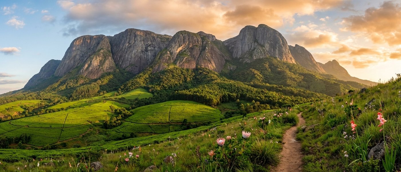
Mount Mulanje is Africa's second-largest inselberg and the highest point in Central Africa, its summit reaching 3,002 metres at Sapitwa Peak. It sits on UNESCO's tentative World Heritage list for its unique geology, its critically endangered Mulanje cedar forests, and its ecological significance as a sky island of endemic species surrounded by lowland plains. The massif covers roughly 650 square kilometres of granite domes, deep river basins, windswept plateaus, and sheer cliff faces that have drawn climbers and hikers for over a century. And yet, compared to Kilimanjaro or the Drakensberg, it remains blissfully uncrowded. On most days, you will have the trails to yourself.
What follows is everything you need to plan your mount mulanje hiking trip: every major route broken down by difficulty, the hut system explained, guides and porters demystified, a packing list built from experience, and practical advice on timing, fees, and safety. We also cover where to stay before and after the hike, because what you do when you come off the mountain matters almost as much as what you do on it.
The Mulanje Massif: Understanding the Mountain
Before you choose a trail, it helps to understand the shape of the mountain. Mulanje is not a single peak. It is a vast plateau system interrupted by granite peaks, river valleys, and basins, the whole thing ringed by near-vertical cliffs that rise abruptly from the surrounding tea plantations and savanna. The main access points are on the western side (Likhubula), the southern side (Lichenya), and the eastern side (Fort Lister). Each gives access to a different section of the massif, and the trails that connect them make multi-day traverses possible.
The plateau sits at roughly 1,800 to 2,200 metres, with individual peaks rising higher. The terrain up top is a mix of montane grassland, rocky outcrops, cedar groves, streams, and occasional tarns. The weather is its own system entirely. Cloud can roll in within minutes, dropping visibility to near zero and temperatures by ten degrees. Even in the dry season, the mountain makes its own rain. Respect it accordingly.
The Mulanje Cedar
You cannot talk about Mulanje without talking about the Widdringtonia whytei, the Mulanje cedar. It is Malawi's national tree, one of the most endangered conifers on the planet, and it exists nowhere else on earth. These slow-growing, aromatic trees once covered large sections of the plateau, their rot-resistant timber so prized that decades of illegal logging devastated the population. Wildfires have done the rest.
Today, scattered groves survive in the more remote corners of the massif, and the Mulanje Mountain Conservation Trust (MMCT) runs an active replanting programme. If you hike the plateau, you will see young saplings growing alongside ancient survivors, their twisted trunks and spreading canopies unmistakable against the granite. It is both beautiful and sobering. The cedar is one of the reasons the mountain has been nominated for UNESCO World Heritage status, and one of the reasons your visit matters: tourism revenue supports the conservation effort that keeps these trees alive.
Where to Register: The Mulanje Mountain Conservation Trust
All hikers must register with the MMCT before heading onto the mountain. The main registration point is the Likhubula Forest Station on the western side of the massif, near Mulanje town. This is where you pay your entry fees, arrange guides and porters, book mountain huts, and log your planned route and expected return date.
Registration is not optional and it is not bureaucracy for the sake of it. The mountain is remote, the weather is unpredictable, and people have died up there. Your registration is what triggers a search if you do not come back when expected. Fill it in honestly, leave a copy of your itinerary with your accommodation, and take it seriously.
Current fee structures vary for international visitors, regional visitors, and Malawian residents. Carry cash in Malawian kwacha, as there are no card facilities at the forest station. The MMCT office can also provide updated information on trail conditions, hut availability, and any closures due to weather or maintenance.
The Trails: Every Major Route on Mount Mulanje
Here is the trail-by-trail breakdown. We have grouped them by difficulty and type so you can find the right mulanje hikes for your fitness level and available time.
Day Hikes
If you have a single day or half day, these are your options. All start from the Likhubula Forest Station unless noted otherwise.
Likhubula Falls
Difficulty: Easy | Time: 1.5 to 2 hours round trip | Distance: ~3 km
The most accessible walk on the mountain and a perfect introduction to Mulanje's lower slopes. The path follows the Likhubula River through dense indigenous forest, thick with mosses, ferns, and epiphytes. After roughly 45 minutes, you reach the falls: a curtain of water dropping into a clear, cold pool surrounded by rocks and forest canopy. You can swim here. Bring a towel.
This trail is suitable for families, older visitors, and anyone who wants a taste of the mountain without committing to a serious climb. The forest itself is beautiful, and the birding is excellent: look for Livingstone's turaco, green twinspot, and bar-tailed trogon in the canopy.
Chambe Basin Viewpoint
Difficulty: Moderate | Time: 5 to 7 hours round trip | Elevation gain: ~800 m
This is the day hike for people who want to earn their views. The trail climbs steeply from Likhubula through indigenous forest and then montane grassland to a viewpoint at the base of the Chambe Face, one of the highest cliff faces in Africa at approximately 1,600 metres of sheer granite. The views from the top are staggering: the Phalombe Plain stretching east, tea plantations rolling away to the south, and the Chambe Face towering above you like a wall built by something older than time.
You need to start early, ideally by 6:00 AM, to avoid afternoon cloud and to give yourself enough daylight for the return. Bring plenty of water, a warm layer, and a rain jacket regardless of the forecast.
Multi-Day Treks
This is where mount mulanje hiking truly reveals its character. The plateau is vast, wild, and connected by a network of trails and mountain huts that make two to five-day traverses possible. Each route offers a different perspective on the massif.
The Classic West-to-East Traverse
Difficulty: Challenging | Duration: 3 to 4 days | Route: Likhubula to Chambe Hut to Thuchila Hut to Sombani Hut to Fort Lister Gap
This is the most popular multi-day route on Mulanje and for good reason. It crosses the heart of the plateau, passing through cedar forest, granite domes, river valleys, and high grassland before descending through the dramatic Fort Lister Gap on the eastern side. The walking is demanding but not technical, and the variety of terrain keeps every day interesting.
Day one typically involves the steep ascent from Likhubula to Chambe Hut (4 to 5 hours). Day two crosses the plateau to Thuchila Hut (5 to 7 hours), passing through some of the most remote and beautiful sections of the massif. Day three continues to Sombani Hut or directly to the Fort Lister descent. A fourth day allows for a more relaxed pace or a detour to Sapitwa summit.
You will need transport arranged at the Fort Lister end, as it is on the opposite side of the mountain from where you started. Your guide can help coordinate this, or ask your accommodation to arrange a pick-up.
Sapitwa Peak Summit
Difficulty: Very Challenging | Duration: Typically added to a multi-day traverse (summit day is 6 to 8 hours return from Chisepo or Thuchila Hut) | Elevation: 3,002 m
Sapitwa is the highest point in Malawi and the highest peak in Central Africa. The name means "don't go there" in the local Lomwe language, which tells you something about the mountain's reputation. The final approach involves scrambling over exposed granite, navigating cairn-marked routes through boulder fields, and, on the last section, some light rock climbing that requires confidence and a head for heights. It is not technically difficult by mountaineering standards, but it is serious hiking, and it is not a place you want to be in bad weather.
A guide is mandatory for Sapitwa. The route is not well marked, the rock can be slippery, and in cloud or mist, navigation becomes extremely difficult. Most hikers summit from Chisepo Hut, starting before dawn to catch sunrise from the top. On a clear morning, you can see Lake Chilwa, the Zomba Plateau, Mozambique, and, on exceptional days, the shimmer of Lake Malawi to the north. It is one of those moments that makes every blister, every aching muscle, every instant noodle dinner in a cold hut feel worthwhile.
Lichenya Plateau Route
Difficulty: Moderate to Challenging | Duration: 2 to 3 days | Route: Southern approach via Lichenya Forest Station to Lichenya Hut
The Lichenya Plateau is the gentler, more accessible side of Mulanje, and it is where we send hikers who want a multi-day experience without the intensity of the Sapitwa circuit. The ascent from the south is less steep than the Likhubula routes, the plateau itself is rolling grassland dotted with wildflowers (spectacular in the wet season), and the hut is well positioned for day walks to viewpoints and nearby peaks.
This is the best route for beginner-to-intermediate hikers who are fit but not experienced mountain trekkers. The terrain is less technical, the navigation is more straightforward, and the sense of space and remoteness is just as powerful as anywhere else on the massif. It is also less frequented than the Chambe-Thuchila circuit, which means you are more likely to have the plateau to yourself.
The Skyline Trail
Difficulty: Very Challenging | Duration: 4 to 5 days | Route: Follows the rim of the massif, connecting multiple huts
The Skyline Trail is Mulanje's most ambitious route: a multi-day traverse that follows the edge of the plateau, with views dropping away on both sides. It connects several huts and crosses some of the most exposed and dramatic terrain on the mountain. This is not a trail for casual hikers. It requires good fitness, experience with multi-day mountain walking, and a guide who knows the route intimately.
The reward is proportional to the effort. The Skyline offers perspectives on the massif that no other route provides: the full sweep of the cliff faces, the distant plains below, and a sense of isolation that is increasingly rare in the age of Instagram-trail hiking. If you have the experience and the time, this is the definitive mulanje hike.
Hut Accommodation on the Mountain
Mulanje's hut system is the backbone of multi-day hiking on the massif. The main huts, maintained by the Mountain Club of Malawi and the Forestry Department with support from the MMCT, are:
- Chambe Hut -- west side, at the base of the Chambe Face. The most popular first-night stop.
- Thuchila Hut -- central plateau, beautifully positioned by a river. A key junction point for routes heading to Sapitwa, Fort Lister, or Lichenya.
- Chisepo Hut -- the staging point for Sapitwa summit attempts. Basic but functional.
- Sombani Hut -- eastern plateau, en route to the Fort Lister descent.
- Lichenya Hut -- southern plateau, the base for Lichenya Plateau walks.
- Minunu Hut -- smaller, less visited, for those seeking solitude.
The huts are basic: stone or brick structures with sleeping platforms, fireplaces, and sometimes a table. There is no electricity, no running water (streams are nearby but water must be treated), and no food service. You bring everything you need: sleeping bag, cooking gear, food, water purification, and a headlamp. The huts are booked and paid for at the Likhubula Forest Station before you ascend.
Despite the simplicity, there is something deeply satisfying about arriving at a mountain hut after a long day on the trail. The fire crackles, the stars come out through the doorway, the river murmurs below, and the mountain feels enormous and close at the same time. It is not luxury. It is something better.
Guides and Porters
Guides are available at the Likhubula Forest Station and at the Lichenya access point. For some routes, including the Sapitwa summit, hiring a guide is effectively mandatory. The trails are not consistently marked, the weather can reduce visibility to near zero, and the consequences of getting lost on the plateau range from an uncomfortable night out to something much worse.
Even on routes where a guide is not strictly required, we strongly recommend hiring one. The local guides have grown up on and around the mountain. They know the shortcuts, the water sources, the sheltered spots when weather turns, and the history and ecology of every section of the massif. The cost is modest and the experience is incomparably richer.
Porters are also available and, for multi-day treks, they are a genuine game-changer. Carrying four days of food, cooking equipment, a sleeping bag, and warm clothing up steep granite trails is hard work. Handing your heavy pack to a porter who can cover the same ground in half the time frees you to actually enjoy the hiking rather than enduring it. Fees should be agreed in advance. Tipping is customary and appreciated.
What to Bring: The Mulanje Packing List
This list is built from experience, not from a generic outdoor gear checklist. Mulanje has its own demands.
For All Mulanje Hikes
- Sturdy hiking boots with ankle support and good grip. The trails are rocky, uneven, and frequently wet. Trail runners are not enough for the plateau.
- At least two litres of water per person, plus purification tablets or a filter for refilling from streams.
- Rain jacket. Non-negotiable, even in the dry season. The mountain creates its own weather and you will get rained on.
- Warm layer: fleece or lightweight down jacket. The plateau sits above 1,800 metres and temperatures drop sharply when clouds roll in or the sun sets.
- Sun protection: hat, sunscreen (SPF 50+), sunglasses. The plateau is exposed and the UV at altitude is fierce.
- Packed lunch, snacks, and enough water for the full day. There is no resupply on the mountain.
- Small first aid kit with blister plasters, antiseptic, and any personal medication.
- Headlamp with fresh batteries. Even on day hikes, a late return through forest in fading light is not fun without one.
Additional Gear for Multi-Day Treks
- Sleeping bag rated to at least 0 degrees Celsius. The plateau huts are unheated, and night temperatures from May to August can drop near freezing.
- Sleeping mat or pad. The hut platforms are hard.
- Lightweight stove and cooking equipment. Bring enough fuel for all your meals plus spare.
- Food for the full duration, plus one extra day in case of weather delays. Dehydrated meals, instant noodles, oats, nuts, energy bars, tea, and coffee are the staples.
- Water purification: tablets, drops, or a pump filter. Stream water on the plateau should always be treated.
- Dry bags or waterproof stuff sacks for all your gear. Afternoon rain is common and a wet sleeping bag at 2,000 metres is a miserable prospect.
- Trekking poles. Not essential but they save your knees on the steep descents, especially the Fort Lister Gap.
- Toilet paper and a trowel. The mountain huts have basic latrines, but you may need to dig a cathole on the trail. Pack out all waste.
Best Time for Mulanje Hikes
The dry season, May to October, offers the best conditions for hiking mount mulanje. Skies are clear, trails are dry, river crossings are manageable, and visibility from the peaks is at its best. June and July are the coldest months on the plateau, with night temperatures occasionally dropping below freezing, but the days are crisp, bright, and perfect for walking.
August to October is the sweet spot for most hikers: warmer days, still dry, and the mountain grasslands turning golden in the late dry season light. September and October can be hazy from bush fires in the lowlands, which may reduce long-distance views.
The wet season, November to April, brings afternoon thunderstorms, mist, and slippery trails, but also the most dramatic scenery: waterfalls at full power, wildflowers blanketing the Lichenya Plateau, and the mountain at its greenest and most atmospheric. River crossings become more challenging and some routes may be impassable after heavy rain. Experienced hikers can manage the wet season, but you need to be comfortable with reduced visibility and rapid weather changes.
March and April are transitional months that can offer good hiking with fewer visitors and lush, green landscapes. The rains are tapering off, the mountain is still green, and you often get clear mornings before afternoon cloud builds.
Day Hikes vs Multi-Day Treks: Which Is Right for You?
This is the question most people wrestling with when they plan their mulanje hikes. Here is an honest breakdown.
Choose a day hike if: you have limited time, you are travelling with children or less experienced hikers, you do not want to carry overnight gear, or you want to combine Mulanje with other activities in the region (tea estates, Thyolo Forest birding, Blantyre day trips). The Likhubula Falls walk and the Chambe Basin viewpoint are both excellent day options that give you a genuine taste of the mountain.
Choose a multi-day trek if: you want the full Mulanje experience, you are reasonably fit and comfortable with mountain camping, and you have at least three days to spare. The plateau is where the mountain reveals its true character, and you simply cannot access that on a day hike. The remoteness, the silence, the scale of the landscape, the nights under enormous skies: these are the things that make mount mulanje hiking unforgettable, and they all require sleeping on the mountain.
If you are unsure, the Lichenya Plateau route is the best introduction to multi-day hiking on Mulanje. It is less steep, less technical, and less committing than the Sapitwa circuit, while still giving you the full plateau experience.
Where to Stay Before and After Your Hike
This is the part of the trip that most guides overlook, and it is the part that makes or breaks the experience. Where you sleep the night before your hike determines whether you start the trail rested and well-fed or groggy and underprepared. Where you sleep the night after determines whether you recover properly or limp onto your next destination still battered.
The Thyolo House: Your Comfort Base for Mulanje
The Thyolo House sits on the historic Conforzi Tea Estate in the Thyolo highlands, about one hour's drive from the Likhubula Forest Station. It is a boutique hotel with five individually designed rooms in a century-old Italian family farmhouse, surrounded by tea plantations, indigenous forest, and the kind of silence that makes you realise how noisy the rest of your life is.
Here is why it works as a Mulanje base.
Before the hike: Arrive the afternoon before, swim in the pool, walk the tea plantation or the forest trail, and eat a proper dinner at the restaurant, where Flavia Conforzi's Italian fusion menu uses ingredients from the estate garden. Go to bed early in clean sheets. Wake up to estate coffee, a full breakfast, and the knowledge that you are starting the mountain rested and properly fed. That matters more than you think when you are three hours into a steep ascent.
After the hike: This is where The Thyolo House really earns its place in your itinerary. You come off the mountain sore, dusty, elated, and probably craving something other than instant noodles. The drive from Likhubula takes about an hour. You arrive, shower, and head straight for the pool. Someone brings you a cold drink. The tension in your shoulders starts to unwind. Dinner is handmade pasta, fresh salads, grilled meats, and whatever Flavia has created that day, served on the veranda overlooking the tea gardens. After three days of trail food in mountain huts, this is not just a meal. It is a restoration.
The Thyolo House also offers experiences that complement a hiking trip perfectly: forest walks through the indigenous woodland bordering the estate, tea plantation tours, and art workshops in Flavia's studio. These are gentle, restorative activities that let your body recover while keeping your mind engaged. They also make The Thyolo House an ideal base if you are travelling with a partner or family who may not want to hike the mountain but still want a rich, memorable experience in the southern highlands.
We can store luggage you do not need on the mountain, help arrange transport to and from Likhubula, and connect you with reliable guides. We have been doing this long enough to know what hikers need, and we are happy to help you plan your itinerary from start to finish.
Accommodation Closer to the Trailhead
In the interest of completeness, here are the options near the mountain itself.
- Kara O'Mula Country Lodge: At the base of the mountain near Likhubula. The closest lodge to the main trailhead. Basic rooms and camping in a forest setting. Well positioned for early starts, but facilities are simple. Do not expect hot water or gourmet food.
- Mulanje town guesthouses: Budget accommodation in Mulanje town, about 20 minutes from Likhubula. Practical for a night before or after, but not places you would choose to linger.
- Camping at Likhubula: There is a basic campsite at the forest station. If you are carrying your own tent and want to be on the trail at dawn, this is the most practical option.
The gap between these options and a proper boutique stay is significant. If you want comfort, character, and a meal worth remembering, The Thyolo House is the clear choice for Mount Mulanje accommodation.
Planning Your Mulanje Hiking Itinerary
Here are two sample itineraries that we recommend to guests. Adjust them to suit your pace, fitness, and available time.
The Three-Day Sapitwa Itinerary
Day 1: Arrive at The Thyolo House. Settle in, swim, explore the estate. Dinner on the veranda. Early night.
Day 2: Breakfast at 6:00 AM. Drive to Likhubula (1 hour). Register, meet your guide and porters. Ascend to Chambe Hut (4 to 5 hours). Settle in, explore the area, early dinner.
Day 3: Trek from Chambe to Chisepo Hut (5 to 6 hours) via the central plateau. Afternoon rest. Prepare gear for the summit.
Day 4: Pre-dawn start for Sapitwa summit (3 to 4 hours up, 2 to 3 hours down to Chisepo). Pack up and descend to Likhubula (4 to 5 hours). Drive to The Thyolo House. Pool. Dinner. Sleep the sleep of the accomplished.
Day 5: Leisurely morning. Forest walk or tea plantation tour. Depart for Blantyre or onward.
The Gentle Mulanje Weekend
Day 1: Arrive at The Thyolo House. Afternoon forest walk and tea tasting. Dinner.
Day 2: Drive to Likhubula. Day hike to Likhubula Falls and lower forest trails (3 to 4 hours). Lunch in Mulanje town. Return to The Thyolo House for pool and dinner.
Day 3: Art workshop with Flavia or visit nearby Satemwa Tea Estate. Depart after lunch.
This second itinerary works beautifully for couples, families, or anyone who wants to experience the mountain without committing to a full plateau trek. You still get the forest, the falls, the scale of the massif, and the best accommodation in the southern highlands.
Safety on Mount Mulanje
Mulanje is a serious mountain. People have died here, from exposure, falls, and getting lost in mist. The mountain's size, its unpredictable weather, and its remote plateau mean that small mistakes can escalate quickly. Take the following seriously.
- Always hike with a guide on unfamiliar routes, and always for the Sapitwa summit. The trails are not consistently marked, and in cloud or mist, navigation is extremely difficult.
- Register at the forest station with your full itinerary and expected return date. This is your safety net.
- Start early. Afternoon cloud, mist, and thunderstorms are common, even in the dry season. Being caught on an exposed ridge in a storm is dangerous.
- Carry enough water and warm clothing. Dehydration and hypothermia are both real risks on the plateau.
- Do not attempt Sapitwa in bad weather. The summit scramble involves exposed rock with significant drop-offs. If cloud rolls in, wait. The mountain will be there tomorrow.
- Tell someone your plans. Leave your itinerary with the forest station, your accommodation, and someone back home.
- Carry a whistle and a headlamp. If you get lost or injured, a whistle carries further than a shout, and a headlamp means you can move after dark if necessary.
Getting to Mount Mulanje
- From Blantyre: About 70 km southeast, roughly 1 hour 15 minutes by road. The road is tarmac and in reasonable condition.
- From The Thyolo House: About 1 hour to the Likhubula Forest Station. We can help with directions or transport arrangements.
- From Lilongwe: About 350 km. Most visitors fly into Chileka Airport near Blantyre and drive from there.
- From Zomba: About 130 km, roughly 2 hours. Combining Mulanje with a visit to the Zomba Plateau is a popular option for hikers spending a week or more in the southern highlands.
If you are coming from Blantyre, the drive passes through the Thyolo highlands, which is why The Thyolo House works so well as a base: you pass right through on the way to the mountain. Stop on the way out, stop on the way back, or both.
Mount Mulanje and the Thyolo Highlands: A Natural Pairing
There is a rhythm to a Mulanje trip done well. The mountain strips things back. It is raw, physical, humbling. The trails demand your attention and your effort. The huts are basic. The food is whatever you carried up. The views are extraordinary precisely because you earned them.
And then you come down. And the rhythm shifts. The Thyolo highlands are gentle where the mountain is fierce. Tea gardens instead of granite. Birdsong instead of wind. A pool instead of a cold stream. A meal cooked with care instead of rehydrated from a packet. The contrast is what makes both experiences richer.
The Conforzi Tea Estate, where The Thyolo House has stood for a century, exists because of the same geological forces that created Mount Mulanje. The altitude, the rainfall, the rich volcanic soils of the Shire Highlands made this corner of Malawi a place where extraordinary things grow, whether that is a tea bush or a three-thousand-metre granite inselberg. When you sit on our veranda on a clear morning, you can see Mulanje on the eastern horizon, its flat-topped profile unmistakable against the sky. It is a reminder that the mountain is always there. And when you have been up there and come back, the tea garden feels like exactly the right place to be.
If you are planning your mulanje hikes and want help building an itinerary, arranging transport, or simply choosing the right trail for your experience level, we are happy to help. Get in touch or message us on WhatsApp to start planning. You can also explore our day trips from Blantyre guide for more ideas on what to do in the southern highlands before or after your time on the mountain.
The mountain will challenge you. The tea garden will restore you. That is the formula, and it works every time.